This photo shows the agricultural method used to transport the material around, and the old bath house, curiously made from a yellow brick, still standing which was demolished in the spring of 1997. It is buried in the bank by the old railyard tracks a little upslope from where the car park is now.
The car park was built using funding from The WDA in 1997, actually right on top of the old colliery car park next to the baths in front of Caretaker Cottage. So when the visitor parks up to run the dog or whatever today they are parking in the same spot as the miner going to work. This photo shows the collection of vehicles typically found there during the restoration work.
Hafod Coal mine to Hafod Country Park: student resources by Huw Crompton
and Gill Burt, December 2012
Or, how to turn a hundred acre domed coal mine tip into a park and nature
reserve if you've not done it before: we had not, but we did the job. Good
luck!
This information is suitable for those wishing to study in detail the process
of the restoration phase, for students of and practitioners in: soil science,
landscape architecture, mineral and mine engineering, restoration project
management, human geography and related fields.
The project to restore Hafod to country park took place after the end of
the working life of the mine and not subject to any planning conditions that
would be in place for a more recent, current or proposed mine. There was a
moral onus on the owners to do something with it, but no formally prescribed
agenda. This situation had many benefits as well as drawbacks.
The benefits were that the after use design was not subject to minimum standards
imposed by planners, and could be better than these, planning standards being
all too often used as maximum standards The restoration design was tailored
to community use in the 1990s rather than to a preconceived plan separated
by some years from the restoration itself. The project team were also able
to be in control of the financial structure of the project in a constructive
way rather than the reverse.
The downside was that the funding situation was start from scratch with no
capital or bond generated by mineral extraction sales, and limits to the scope
of the project created by the lack of generous finance
The professional expertise required to put together the restoration package
was: soil scientist, landscape architect, geologist, minerals scientist, mining
engineer, safety officer, consultation officers, grants and fundraising officers,
and project managers. Many of these tasks were carried out by the same person
and the project team numbered around 6 to 10 core staff and any one time.
The long term ownership and maintenance were key factors in the design stage
and Hafod was to be given to the public in perpetuity for the enjoyment of
the local communities. No part of the mine footprint was to be sold and only
a very small part was suitable for development. Other mines in the former
coalfields have had long term problems in this respect (for example Rothwell
Colliery in Leeds)
The consultation stage involved as many community groups and possible user
groups as possible. In 1995, the actual use was for trials bikes and little
else, this activity as trespass without the owner's permission, and this excluded
other potential user groups.
From the outset, the use of Hafod as a nature reserve/woodland with good
access and a footpath, route network and multiple leisure uses, was a self
suggesting design, Hafod being a 41m high hill covering 36Ha on a large flat
flood plain offering views of up to 40 miles in most directions. A woodland
with walks is a typical afteruse of many coal tips especially where they are
in close proximity to communities that can make good use of them in this way.
The scope of the restoration project 1995-7 did not include anything in the
way of interpretation or art to permanently commemorate the life of the mine
or the men working there. This section of work, often included in restoration,
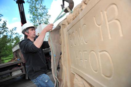
was shelved to be tackled in the future first with the stone summit sculpture
in 2005 and then with more a comprehensive interpretation project in 2012.
Before the mine began working in the 1860s, a number of footpaths and bridleways
had crossed Hafod when it was farmers' fields. Reinstating these links, and
joining in with surrounding track networks, was possible in the footpath network
design, using them as the starting point to make these more elaborate.
The footpaths and tracks were constructed with pedestrians, horse riders,
cyclists, and maintenance access in mind. Theoretically, tracks to be used
for timber extraction were designed, although the project was never realistically
commercially viable tree planting for timber production. In practice, many
of the tracks around and upon the tip already in situ and those from the former
use of the mine were ideal for the new access network. This included the old
railway sidings line and steeper tracks used by euclids (large quarry trucks)
either for ascent (gentle gradients) or descent (steeper gradients). Other
historic features such as the line of a former rope race, were desirable to
keep with the tracks.
New tracks, especially those to directly serve the desires of walkers wishing
to easily gain good views and have a short enjoyable walk were formed. At
the time the gradient used for these was up to 1 in 12. Other tracks provided
shallower gradients and combined with surface water drainage ditches.
Most of the tracks of different kinds were formed using bare coal tailings
shaped to form a free draining berm in cross section. This was later perceived
as a weakness of the restoration and subsequently, key sections of path have
been surfaced in rolled stone and geotextile. At 2012, about 1.5km are surfaced,
leaving 80% unsurfaced. In wet weather some of the unsurfaced paths are muddy
and require the walker to wear wellies! In dry weather there is no such issue.
Soil creation, and storm drainage, were the other priority design issues.
The soil scientist and landscape architect studied similar mines in South
Wales to gain current good practice models. Coal mine tips are susceptible
to storm scouring, being wholly made up land, and lack the stone core found
at similar sized hills locally such as Beeston Castle (sandstone) and Dinas
Bran (limestone). In the 1970s and 1980s Hafod had been spread out and reshaped
to make it safe in aftermath of the Aberfan disaster.
The drainage design was based on a restored mine in South Wales and the design
of this item at Hafod was based upon this project, thanks here to Mervyn Davies.
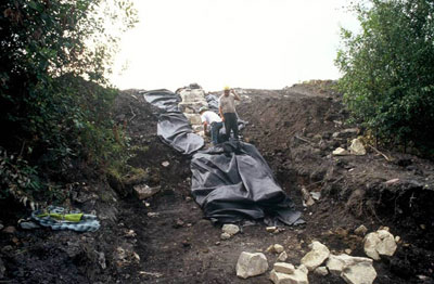
This detail used rock armoured geotextile storm drains to all surface water
drains steep than 1 in 100, where water might be moving at speed in thunderstorm
conditions. Large sandstone blocks around 250mm were laid on top of the geotextiles,
and made to look natural The need for the storm drainage was particularly
acute in the first 10 years after the tree planting and since then tree roots
have effectively bound and stabilised the majority of the surface area at
Hafod.
Attenuation or retention ponds were created in several places around the
lower areas of the park, to retain surface water runoff, manage the quality
and flow of water running off into existing water courses at the base of the
park, and allow silts and solid material carried off the tip to deposit in
the ponds before entering the water courses in the surrounding countryside.
These ponds were designed with wildlife as well as surface water drainage
management in mind.
Four main types of soil creation were used: deep dig to 1m depth and improve
with liquid sewage injection (tree areas); deep dig to 1m depth and improve
with digging in dried sewage sludge (tree areas), deep dig to 1m and improve
with digging in wood residue (tree areas), and shallow harrow to 200mm and
improve with wood residue and dried sewage sludge (meadow and open areas)
The deep dig took 30 diggers 6 weeks over the whole site about 75% by area.
The deep dig was to provide enough structure in the new soil for the trees'
roots to be able to penetrate with enough nutrients and water for them to
grow well, but not support a competing herb layer. The application rate was
100L per m2 for the deep dig areas and 20L per m2 for the shallow harrow areas.
The method for application of the liquid sewage was to use a tracked vehicle
(to minimise compaction of deep dug shale) pulling a purpose built specialised
tine which injected liquid sewage deep into the root layer of the deep dug
shale. This involved a very long hose carrying the sewage from tankers to
the injection tine. Care had to be taken to ensure the sewage remained in
the deeper layers of the shale rather than running over the surface. This
method had been pioneered in South Wales with some success. Liquid injection
was only used on small areas of the tip and the use of dried sewage in sacks
was the main one by area.
The method for the application of the dried sewage sludge was to deposit
sacks around the site, then to slit, lift and swing the sacks to spread the
sludge, prior to the deep dig which was called 'the intimate mix'. The sewage
was inert and odourless at each stage wet or dry, before and after incorporation,
and any reports of 'sewage smells' from this stage of the restoration were
not based on fact.
The tree species planted were those mainly native to NE Wales. The tree species
used were as nurses: larch, pine, birch and alder. These were intended to
be removed in batches at years 10, 20 and 30 or thereabouts. As broadleaved
woodland oak, bird cherry, gean, field maple, willow, rowan. The trees were
planted as 25mm paper pot transplants, very small potted stock. As shrubs:
gorse, hawthorn, broom, scotch rose, viburnum were planted. In the car park,
dwarf pines and a mix of the trees found on site were used. A small number
of horse and sweet chestnut were added to the mix. Willows were used more
extensively above two former lagoons most recently in use, because of a higher
water table in this location and a perceived need to speed up the drying out
process.
Tree spacings were generally 3m centres for the hardwoods, 2m for the softwoods
and 1m centres for the shrubs. Some areas of Hafod have not been planted to
these spacings, as a result of one contractor using operatives unfamiliar
with the type of work. Most of the planting was carried out before easter
1997 by skilled experienced operatives.
The tree planted area to open areas ratio was about 75% to 25%. The open
areas included around 5m either side of the tracks, around the ponds, clearings
at the top and bottom, and an open elevated basin on the west side
Local provenance was specified in the contract documents. This means trees
grown from locally sourced seed. In practice, the numbers needed, and cost
cutting contractors on the job, meant that this was not the case and trees
sourced in Poland and elsewhere arrived on site. Neighbouring trees of the
same species can be seen to have different leafing out times and other differences
such as leaf shape and habit.
 The post-completion tree growth has been very rapid 1997 to 2012. The nurse
crop is ready for removal in most areas and in some locations is likely to
obstruct views, as well as swamp slower growing trees. If the nurse crop is
not removed before year 20 then the trees will be too large to be removed
without damaging the neighbouring trees.
The post-completion tree growth has been very rapid 1997 to 2012. The nurse
crop is ready for removal in most areas and in some locations is likely to
obstruct views, as well as swamp slower growing trees. If the nurse crop is
not removed before year 20 then the trees will be too large to be removed
without damaging the neighbouring trees.
Comparative growth rates are visibly smaller trees in the upper and more
exposed sections of Hafod and larger trees in the lower and more sheltered
sections. On the steeper slopes, trees have shaped themselves to the local
topography with leaning trunks and branches running parallel with the ground.
In many areas, the stone armoured drains have proved to be very suitable
places for self seeding and regeneration, particularly the birch, alder and
willow. This has been left largely unmaintained.
The restoration project has been a success at Hafod thanks to a combination
of factors not the least of which is the long term commitment of the current
owners. Given that the tips at Bersham (going) and Llay (gone) no longer commemorate
the importance of the North Wales Coal fields, the fact that Hafod tip is
still there in a similar form to when the mine closed, makes Hafod more important,
representing the landscape and cultural impact of the whole of the coal field,
even though there are no remaining surface buildings.
Space exists for more elaborate visitor facilities on level ground just to
the south of the existing car park, should future conditions prove to be favourable
for this, particularly in the context of the short term prospects very close
by at Bersham and its very good surface buildings.

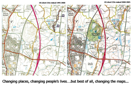 Although less striking in profile than Bersham, the tip was a hill of the same height and mostly purple grey colour with very little vegetation, not much use to the people in Rhos and Johnstown, and really an eyesore especially from the recently built A483.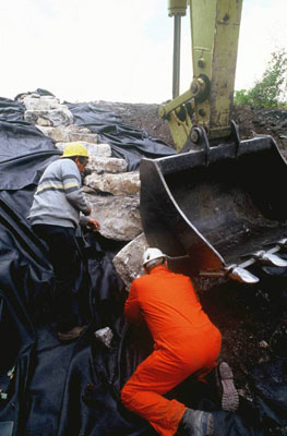
 Many interesting objects appeared, all waste from the mine (for example pit pony bones and broken old wheeled tubs) went onto the tip not just low grades of coal and stone. To form the new soil, great quantities of odourless dried sewage cake in granule form delivered in sacks were dug into the new soil structure.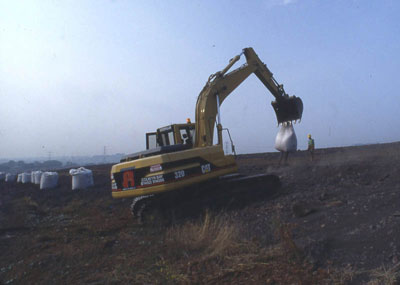
 The open areas to become meadow were improved, again using agricultural methods. A spring tine cultivator was used for the top 200mm, much shallower than the 1m needed for the trees and their much deeper roots, the sack in the background is full of dried sewage sludge.
 80,000 trees were planted at the end of the winter in 1997. The nursery stock arrived in trays carried by vans, the trees were tiny, in little paper pots, like this pine that is being planted in the spring. An early idea to enclose the tree plots in rabbit proof fencing was dropped. It’s fair to say that the project team at that time really had little idea how successful the take on the trees would be and how many would survive and flourish.